Ashwin Sivakumar is this year’s recipient of Pasadena Audubon’s coveted Conservation Hero Award.
Beyond being a Board Member for Conservation and Advocacy, Ashwin especially distinguished himself this year with his leadership of our Chapter’s Pasadena Street Tree Project, highlighting many species of trees purposely chosen to invite and sustain our local birds as well as meet the City’s unique requirements for street trees planted on public property. He did extensive research, prepared documentation, and persuasively presented the information to influencers and decision makers in Pasadena. He continues to advocate and fine-tune the program.
As you may know, Ashwin will be attending Harvard University in the Fall. We all wish him the very best in the next chapter of his life journey.
Congratulations, Ashwin. Take a virtual bow!
Dave Weeshoff, PAS Vice-President
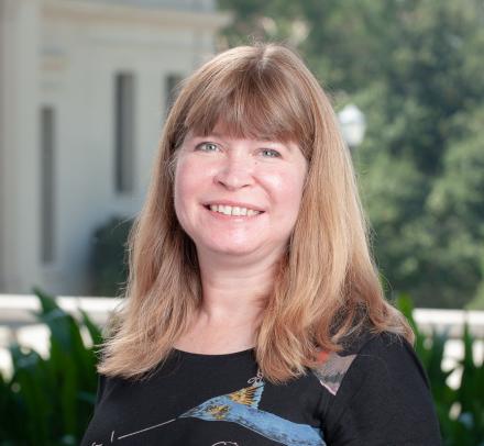
Kathy Degner - Education
It is our pleasure to present the Education Hero Award for 2022 to Kathy Degner. She has done more to educate the public, school children, and our Young Birders than anyone we can imagine.
As Outreach Chair, she created many activities to engage families and the public, including creating the world -famous Wheel of Birding. For years, she has shared this at many outreach events all over the region.
She is also a co-creator of the Bird Science Program, and as such, she developed curriculum and activities, bringing her friend Albie ion the classroom to teach children about plastic pollution. She designed the field trips, has taught many of the classes, helped develop our docent and intern training, and mentors our interns. She is an integral part of sharing the raptors from Wild Wings and can usually be seen at our BSP field trips with an owl on one arm.
Kathy is also a developer of our new and improved Young Birders Club, creating activities and curriculum, leading field trips, and being indispensable and beloved by the kids.
Kathy's passion for bird (and otter!) conservation imbues her education work, and we are beyond grateful to her contributions to our education programs, but more importantly, to our kids and our community. Thank you, Kathy!
Laura Solomon, past president, PAS
Darren Dowell - Birding
As editor of Wrentit, and as a member of the Awards Committee, it is once again my privilege to introduce this year’s Birding Hero, although really our winner needs no introduction.
He’s one of our rockstar field trip guides, he’s served on the PAS Board both as the Veep and as Programs Chair for most of the last decade, and his birding expertise shines in key site descriptions and other content he wrote for our .
I’m writing, of course, about Darren Dowell. And if all that weren’t heroic enough, there’s more: For years, Darren Dowell has been “the eyes and ears” of Hahamonga Watershed Park. He’s submitted 3700 ebird checklists within LA County, and most of those are from Hahamongna (29 so far this year alone). His dedication to birding this important patch of bird habitat has not only been helpful for letting our community know when some exciting rarities show up, it was also critical to Pasadena Audubon’s settlement with LA County to reduce the scope of the Big Dig sediment removal project at Devil’s Gate Dam. From his extensive experience birding Hahamonga, Darren knew the Big Dig as originally conceived would destroy nesting sites of the threatened Bell’s Vireo. Now, instead of bulldozing, that area will have bird blinds installed to facilitate the unobtrusive appreciation of our local avifauna. Kudos, Darren!
Carl Matthies, Wrentit editor
Patrick Walling - Break-out Volunteer Extraordinaire!
Patrick Walling joined us as a volunteer about 2 years ago. With a background in art direction for glossy magazines and in creating a coherent look to all communications pieces of an organization, I knew that he would be a huge asset.
Not only has Patrick redesigned our general brochure, the impact report, the garden brochure, he also stepped right up when the book committee formed and he stuck with it for 18 months. Always a calm and even-keeled voice in discussions even when revisions meant more, sometimes a lot more, work for him. The result, you’ve all seen, is really so much more than what we’d initially imagined. And we are so grateful. The bookmark was another Patrick creation as was the beautiful enamel PAS pin.
Thank you, Patrick for your amazing work and dedication to PAS!!
Lois Brunet, PAS Executive Director
Mickey Long - Longtime Volunteer Extraordinaire!
I’ve been with PAS since 2016 and of course Mickey was on the board when I joined the following year. Confident and quiet, always a voice of reason, I’ve really enjoyed getting to know him and discovering his extensive talents, experience and expertise.
Mickey has been volunteering with Pasadena Audubon for 40 plus years, many on the board, but also with several of our sister organizations:
• Arroyos & Foothills Conservancy – on the board as Biology Advisor
• California Native Plant Soc., San Gabriel Mtns. – where he was a founding member
• ECNCA – where he continues to teach various sections of the docent training class
Mickey has been PAS Conservation Chair, VEEP, President and field trip leader. He’s also taught various classes including Sparrows and Birds & Botany. This year, he co-chaired the book committee, a monumental task, shepherding this collaborative effort through to its successful conclusion.
Mickey finally left the PAS board this Spring but continues to graciously share his expertise and which is a great thing for the chapter and for me. Whenever I get a strange bird photo or question that I can’t answer, I know I can always send it to Mickey and am sure to learn something.
One final word, in case you didn’t notice, we meet in the Mickey Long Auditorium, so named because of the support Mickey provided which was key in the rebuilding of the nature center the Station Fire in 2009.
Mickey, for all you’ve done and continue to do. Our heartfelt thanks.
Lois Brunet, PAS Executive Director
2021 Pasadena Audubon Heroes
Tim Brick - Conservation
We chose Tim Brick to be our Conservation Hero for 2021 because of his decades of fiercely and persistently defending the Arroyo Seco. The mission of the Arroyo Seco Foundation, of which Tim is the Managing Director, is to protect and restore the Arroyo Seco, and we cannot think of anyone who is a more stalwart champion of the Arroyo Seco than Tim. Tim works diligently to protect natural and native habitat, which means he protects birds.
Tim has also motivated the Pasadena Audubon Society to fight the good fight to protect the Arroyo Seco, and fought with us should to shoulder to keep athletic fields out of Hahamongna Watershed Park and to improve the misguided Big Dig. We are grateful to Tim for inspiring us to become vigorous defenders of birds and bird habitat, and we are honored to partner with the Arroyo Seco Foundation. Thank you, Tim. We look forward to restoring the Arroyo Seco with you.
Laura Solomon, PAS President
Vicki Salmon - Education
When we did our first docent training series in 2019 for the Bird Science Program, I was really happy to see that many of the new volunteers had experience in elementary school education. The program is half in the classroom, half at Peck Park, so strong classroom skills is a big plus.
Vicki was one of these recently retired teachers, with decades of classroom experience as a music teacher. How lucky were we?? In addition, Vicki has a remarkably sunny personality, as anyone who knows her will say. She’s always got a warm smile and a positive view on things. She was a key volunteer in that year and I personally really enjoyed working with her.
After the pandemic shut things down, and with Taylor moving to full time paid work, our core team (Kathy Degner, Laura Solomon and I) needed a new addition, we asked our team of docents and Vicki stepped right up!
First order of business has been reworking the docent training class so that non-birders can learn enough about the birds themselves to join as confident docents. In our first meeting Vicki offered to write the curriculum, using her knowledge of the program and her expert understanding of how we learn best – mostly by doing. We’re powering ahead and I am so grateful to have Vicki at the table. Our docent training class is now going to be 5 sessions, 3 hours each and thanks to Vicki, it’s going to be amazing. So grateful for her enthusiasm and generosity and looking forward to a great year with Vicki in the leadership team.
Thank you Vicki!
Lois Brunet, PAS Program Director
Marsha Fowler - Birding
Our inaugural Birding Hero Award goes to someone who took the giant sour lemon of the pandemic and made a sweet batch of lemonade by birding her own yard every single day of 2020. For her dedication she was featured in the February Wrentit, and in that interview she expressed an intention to continue the streak in 2021. As of halfway through June she has made good on that pledge. This is a real accomplishment not just for having honed her bird ID and photography skills, but for the valuable contribution it makes to citizen science. She’s recorded all these observations in eBird, giving the Cornell Lab several hundred snapshots that together provide an extremely detailed portrait of a suburban residence in the foothills of the San Gabriel Mountains. And a lively little patch it is, visited by mourning doves, finches, juncos, towhees, chickadees, warblers, crows, the occasional Cooper’s Hawk, and the Red-crowned Parrots we know Marsha is inordinately fond of. Congratulations, Martha, and keep up the good work!
Carl Matthies, Wrentit editor
Graham Hamby - Break-out Volunteer Extraordinaire!
Back when we were still at Eaton Canyon, and Doug Farr was Hospitality Chair, I noticed a charming couple helping out at all the meetings, setting out cookies, making coffee and just being helpful. So I went and said hello. Graham Hamby and Sherra Fermino were new to PAS but they’d jumped right in. In getting to know them, I learned that Graham had lots of ideas for making Pasadena Audubon more welcoming and more hip! And he was willing to help!
So, when we were kicking off the Bird Science Program, and needed a logo and bird cards with Western Birds in them, I asked him to take on both and he did. Then one day I went to pick up a proof at their house and Graham showed me an amazing 5 foot segment of a telephone pole which had been transformed into an Acorn Woodpecker granary, which they had in their yard! We were doing the garden at the time, and I said, oh can we have that for the opening day – it would be so cool – such a symbol for birds in the urban environment. They donated and delivered it!
When Lois Fulmer stepped off the board last summer, Membership seemed like the perfect fit for Graham and he accepted. He’s done a lot of work there, including creating the PAS enamel pin with our volunteer designer Patrick Walling. He’s involved with multiple projects including the book project, the nominations committee and strategic planning. I’m sure I’m forgetting something. It’s a such a pleasure to work with such a dedicated volunteer and his charming partner, Sherra.
Thank you Graham for all you do!!! We couldn’t be luckier!
This award is reserved for extraordinary volunteers who have given their time and talents to the Pasadena Audubon Society for years. In fact, we may not be able to award it every year. But for our first ever Long-time Volunteer Award, the choice was obvious. Elaine MacPherson has dedicated years of service to Pasadena Audubon as board secretary, a field trip leader, including leading the monthly trip at the Huntington Library for almost ten years, and as the Voice of Pasadena Audubon for at least 25 years. This means she was faithfully answering phone calls from our members as well as the general public, and these could be challenging. She also helped shepherd the chapter through a difficult time many years ago. For her tireless dedication and service, we are grateful. Thank you, Elaine, for being so supportive, cheerful, and dedicated!
Laura Solomon, PAS President
Crow Cup
The Crow Cup is awarded for extraordinary service to Pasadena Audubon.
Congratulations to the 2020 Crow Cup recipient, Janet Scheel!
Past Crow Cup recipients
Year
Recipient
2020
Janet Scheel
2019
Mark Scheel
2018
Susan Gilliland
2017
Grace Wong
2016
Lois Fulmer
2015
Mark Hunter
2014
Hill Penfold
2013
Jon Fisher
2012
Elaine McPherson
2011
John Garrett
2010
Norm Arnheim
2009
Will Fulmer
2008
Laura Garrett
2007
Bev McKenzie
2006
Ron Cyger
2005
Jon Feenstra
Wrentit Club
Before its retirement at the end of 2020, the Wrentit Club honored the Pasadena Audubon members who spotted the most bird species in LA County in a calendar year.
Chris Dean 388
Mark Scheel 387
Naresh Satyan 376
Janet Scheel 363
Dessi Sieburth 349
Frank Gilliland 346
Susan Gilliland 340
Merryl Edelstein 308
Kimball Garrett 304
Larry Schmahl 301
Judi Hwa 283
Luke Tiller 284
Lance Benner 278
Jon Fisher 278
Marvin Nelson 273
Jane Stavert 272
Kathi Ellsworth 270
David Bell 270
Tom Cassaro 269
Jon Feenstra 268
Darren Dowell 263
Javier Vazquez 261
Michael Long 255
Kim Moore 252
Wrentit Club 2019
250+ The Wrentit Club
Chris Dean 393
Mark Scheel 383
Janet Scheel 349
Dessi Sieburth 348
Naresh Satyan 344
Frank Gilliland 328
Javier Vazquez 314
Kimball Garrett 295
Susan Gilliland 295
John Garrett 289
Merryl Edelstein 288
Darren Dowell 279
Michael Long 278
Jon Feenstra 275
Kim Moore 274
David Bell 264
Graham Hamby 258
Debbie C. 255
Judi Hwa 254
Jon Fisher 250
Wrentit Club 2018
250+ The Wrentit Club
Mark Scheel 403
Chris Dean 395
Dessi Sieburth 392
Janet Scheel 366
Naresh Satyan 334
Kimball Garrett 317
Mickey Long 316
Darren Dowell 315
Javier Vasquez 312
Frank Gilliland 309
Merryl Edelstein 307
John Garrett 300
Susan Gilliland 295
Kim Moore 294
Jan Long 283
Jim Moore 282
Grace Wong 282
David Bell 274
Judi Hwa 272
Larry Schmahl 263
Luke Tiller 261
Lance Benner 260
Jon Fisher 257
Elaine MacPherson 255
Nancy Strang 255
Jon Feenstra 251
Wrentit Club 2017
100-149 The Rails
150-199 The Vireos
John Lobel 185
John Birsner 191
Katie Riggs 196
Rob McLean 198
200-249 The Owls
Ron Cyger 201
Kathi Ellsworth 204
Judy Howell 211
Ira Blitz 214
Julia Ray 217
Bas van Schooten 230
M Kwan 235
Lois Brunet 236
Jan Long 248
250+ The Wrentit Club
Elaine McPherson 250
Dan Cooper 252
Lance Benner 256
Jon Fisher 261
Grace Wong 264
Ed Stonick 269
Javier Vasquez 269
John Garrett 270
Nancy Strang 274
Susan Gilliland 280
Frank Gilliland 282
Luke Tiller 284
Jon Feenstra 290
Mickey Long 301
Yonghee Lee 302
Darren Dowell 302
Merryl Edelstein 303
Kimball Garrett 345
Janet Scheel 354
Chris Dean 363
Dessi Sieburth 365
Mark Scheel 374
Wrentit Club 2016
100-149 The Rails
Katie Riggs 102
Lois and Pascal Brunet 141
150-199 The Vireos
Mark Hunter 189
200-249 The Owls
Lois Fulmer 204
Will Fulmer 205
Jane Stavert 217
Javier Vazquez 217
Laura Garrett 218
Kathi Ellsworth 218
Catherine Hamilton 220
Dan Cooper 227
Bas van Schooten 229
Naresh Satyan 223
Ron Cyger 233
Ed Stonick 234
Jon Fisher 248
250+ The Wrentit Club
Jan Long 251
Julia Ray 257
John Garrett 262
Lance Benner 269
Grace Wong 270
Elaine McPherson 273
Merryl Edelstein 273
Mei Kwan 289
Mickey Long 292
Kimball Garrett 302
Darren Dowell 310
Jon Feenstra 310
Luke Tiller 311
David Bell 317
Susan Gilliland 320
Gabriel Gartner 321
Frank Gilliland 326
Yonghee Lee 333
Amy Williamson 334
Dessi Sieburth 357
Janet Scheel 357
Mark Scheel 372
Wrentit Club 2015
100-149 The Rails
None
150-199 The Vireos
Katy Mann 167
Lois and Will Fulmer 171
Rob MacLean 184
Norm Vargas 199
John Rogers 250
Jon Fisher 252
Ron Cyger 253
Ed Stonick 258
Julia Ray 261
Catherine Hamilton 265
Yonghee Lee 274
Lance Benner 275
John Garrett 280
Grace Wong 281
Elaine McPherson 288
Jan Long 293
Mei Kwan 294
Luke Tiller 300
Mickey Long 313
Jon Feenstra 313
Darren Dowell 334
Nancy Strang 340
Susan Gilliland 347
Frank Gillilland 351
Amy Williamson 359
Dessi Sieburth 362
Janet Scheel 363
Mark Scheel 371
Wrentit Club 2014
WC/CBC
Darren Dowell 226
50-99 The Finches
None
100-149 The Rails
None
150-199 The Vireos
Christopher Stevenson 176
Linda Moore 179
Laura Moser 182
Lois and Will Fulmer 184
Judy Bass 186
Ira Blitz 186
Luke Tiller 187
Marilynn Hildebrandt 190
Norm Vargas 191
Catherine Hamilton 194
200-249 The Owls
Beatrix Schwarz 226
Kathi Ellsworth 246
250+ The Wrentit Club
Laura Garrett 250
Ron Cyger 250
Julia Ray 260
Jon Fisher 270
Kevin Long 274
Jared Knickmeyer 275
Pam Dong 279
Elaine McPherson 279
John Garrett 295
Jan Long 298
Lance Benner 300
Jon Feenstra 312
Grace Wong 313
Lynda Elkin 319
Dessi Sieburth 321
Mickey Long 324
Darren Dowell 326
Mei Kwan 330
Nancy Strang 333
Susan Gilliland 345
Frank Gilliland 348
Amy Williamson 349
Brittany O’Connor 351
Janet Scheel 352
Mark Scheel 361
Wrentit Club 2013
WC/CBC
Darren Dowell (PAS CBC circle) 260
50-99 The Finches
None
100-149 The Rails
None
150-199 The Vireos
Wendy Gordon 165
Deni Sinnott 170
Laura Moser 189
Mark Hunter 191
Lois and Will Fulmer 198
200-249 The Owls
Norm Vargas 205
Catherine Hamilton 207
Kathi Ellsworth 215
Luke Tiller 226
Karen Brumer 230
Layton Price 236
Kevin Long 249
250+ The Wrentit Club
John Rodgers 250
Ron Cyger 258
Laura Garrett 259
Jan Long 266
Beatrix Schwarz 271
Grace Wong 274
Julia Ray 274
Dessi Sieburth 280
Pam Dong 280
Jon Fisher 280
Amy Williamson 285
Jared Knickmeyer 287
Elaine MacPherson 294
Lance Benner 306
Mei Kwan 311
John Garrett 313
Jon Feenstra 317
Brittany O'Connor 319
Michael Long 319
Lynda Elkin 321
Nancy Strang 328
Darren Dowell 342
Susan Gilliland 355
Frank Gilliland 358
Janet Scheel 361
Mark Scheel 369
Wrentit Club 2012
100-149 The Rails
None
150-199 The Vireos
Mark Hunter 152
E.J. Remson 168
Kevin Long 173
Linda Moore 173
Tori Collendar 181
Brendan Crill 185
Ximena Gil 193
Jan Long 196
200-249 The Owls
Grace Wong 204
Laura Moser 214
Will Fulmer 215
Lois Fulmer 216
Mei Kwan 216
Amy Williamson 220
Tracy Drake 226
Beatrix Schwartz 227
Pam Dong 231
Dessi Sieburth 233
Lee Pace 237
Kathi Ellsworth 239
250+ The Wrentit Club
Norm Vargas 250
John Rodgers 251
Mickey Long 268
Laura Garrett 269
Jon Fisher 275
Julia Ray 276
Lance Benner 281
Elaine MacPherson 285
Jon Feenstra 291
Ron Cyger 300
John Garrett 301
Nancy Strang 310
Susan Gilliland 352
Janet Scheel 352
Frank Gilliland 353
Darren Dowell 356
Mark Scheel 364
Wrentit Club 2011
100-149 The Rails
Ed Stonick 114
Pam Dong 140
Deni Sinnott 140
E.J. Remson 145
Mark Hunter 148
Lois Fulmer
Will Fulmer
Kathi Ellsworth 206
Mickey Long 211
Lance Benner 238
Brendan Crill 248
250+ The Wrentit Club!
Elaine McPherson 251
Laura Garrett 258
Nancy Strang 281
Julia Ray 268
Norm Vargas 271
Jon Fisher 279
Ron Cyger 297
Darren Dowell 308
Janet Scheel 314
Susan Gilliland 316
Frank Gilliland 318
Jonathan Feenstra 322
John Garrett 328
Mark Scheel 329
2022 Pasadena Audubon Heroes
Ashwin Sivakumar - Conservation
Ashwin Sivakumar is this year’s recipient of Pasadena Audubon’s coveted Conservation Hero Award.
Beyond being a Board Member for Conservation and Advocacy, Ashwin especially distinguished himself this year with his leadership of our Chapter’s Pasadena Street Tree Project, highlighting many species of trees purposely chosen to invite and sustain our local birds as well as meet the City’s unique requirements for street trees planted on public property. He did extensive research, prepared documentation, and persuasively presented the information to influencers and decision makers in Pasadena. He continues to advocate and fine-tune the program.
As you may know, Ashwin will be attending Harvard University in the Fall. We all wish him the very best in the next chapter of his life journey.
Congratulations, Ashwin. Take a virtual bow!
Dave Weeshoff, PAS Vice-President
Kathy Degner - Education
It is our pleasure to present the Education Hero Award for 2022 to Kathy Degner. She has done more to educate the public, school children, and our Young Birders than anyone we can imagine.
As Outreach Chair, she created many activities to engage families and the public, including creating the world -famous Wheel of Birding. For years, she has shared this at many outreach events all over the region.
She is also a co-creator of the Bird Science Program, and as such, she developed curriculum and activities, bringing her friend Albie ion the classroom to teach children about plastic pollution. She designed the field trips, has taught many of the classes, helped develop our docent and intern training, and mentors our interns. She is an integral part of sharing the raptors from Wild Wings and can usually be seen at our BSP field trips with an owl on one arm.
Kathy is also a developer of our new and improved Young Birders Club, creating activities and curriculum, leading field trips, and being indispensable and beloved by the kids.
Kathy's passion for bird (and otter!) conservation imbues her education work, and we are beyond grateful to her contributions to our education programs, but more importantly, to our kids and our community. Thank you, Kathy!
Laura Solomon, past president, PAS
Darren Dowell - Birding
As editor of Wrentit, and as a member of the Awards Committee, it is once again my privilege to introduce this year’s Birding Hero, although really our winner needs no introduction.
He’s one of our rockstar field trip guides, he’s served on the PAS Board both as the Veep and as Programs Chair for most of the last decade, and his birding expertise shines in key site descriptions and other content he wrote for our .
I’m writing, of course, about Darren Dowell. And if all that weren’t heroic enough, there’s more: For years, Darren Dowell has been “the eyes and ears” of Hahamonga Watershed Park. He’s submitted 3700 ebird checklists within LA County, and most of those are from Hahamongna (29 so far this year alone). His dedication to birding this important patch of bird habitat has not only been helpful for letting our community know when some exciting rarities show up, it was also critical to Pasadena Audubon’s settlement with LA County to reduce the scope of the Big Dig sediment removal project at Devil’s Gate Dam. From his extensive experience birding Hahamonga, Darren knew the Big Dig as originally conceived would destroy nesting sites of the threatened Bell’s Vireo. Now, instead of bulldozing, that area will have bird blinds installed to facilitate the unobtrusive appreciation of our local avifauna. Kudos, Darren!
Carl Matthies, Wrentit editor
Patrick Walling - Break-out Volunteer Extraordinaire!
Patrick Walling joined us as a volunteer about 2 years ago. With a background in art direction for glossy magazines and in creating a coherent look to all communications pieces of an organization, I knew that he would be a huge asset.
Not only has Patrick redesigned our general brochure, the impact report, the garden brochure, he also stepped right up when the book committee formed and he stuck with it for 18 months. Always a calm and even-keeled voice in discussions even when revisions meant more, sometimes a lot more, work for him. The result, you’ve all seen, is really so much more than what we’d initially imagined. And we are so grateful. The bookmark was another Patrick creation as was the beautiful enamel PAS pin.
Thank you, Patrick for your amazing work and dedication to PAS!!
Lois Brunet, PAS Executive Director
Mickey Long - Longtime Volunteer Extraordinaire!
I’ve been with PAS since 2016 and of course Mickey was on the board when I joined the following year. Confident and quiet, always a voice of reason, I’ve really enjoyed getting to know him and discovering his extensive talents, experience and expertise.
Mickey has been volunteering with Pasadena Audubon for 40 plus years, many on the board, but also with several of our sister organizations:
• Arroyos & Foothills Conservancy – on the board as Biology Advisor
• California Native Plant Soc., San Gabriel Mtns. – where he was a founding member
• ECNCA – where he continues to teach various sections of the docent training class
Mickey has been PAS Conservation Chair, VEEP, President and field trip leader. He’s also taught various classes including Sparrows and Birds & Botany. This year, he co-chaired the book committee, a monumental task, shepherding this collaborative effort through to its successful conclusion.
Mickey finally left the PAS board this Spring but continues to graciously share his expertise and which is a great thing for the chapter and for me. Whenever I get a strange bird photo or question that I can’t answer, I know I can always send it to Mickey and am sure to learn something.
One final word, in case you didn’t notice, we meet in the Mickey Long Auditorium, so named because of the support Mickey provided which was key in the rebuilding of the nature center the Station Fire in 2009.
Mickey, for all you’ve done and continue to do. Our heartfelt thanks.
Lois Brunet, PAS Executive Director
2021 Pasadena Audubon Heroes
Tim Brick - Conservation
We chose Tim Brick to be our Conservation Hero for 2021 because of his decades of fiercely and persistently defending the Arroyo Seco. The mission of the Arroyo Seco Foundation, of which Tim is the Managing Director, is to protect and restore the Arroyo Seco, and we cannot think of anyone who is a more stalwart champion of the Arroyo Seco than Tim. Tim works diligently to protect natural and native habitat, which means he protects birds.
Tim has also motivated the Pasadena Audubon Society to fight the good fight to protect the Arroyo Seco, and fought with us should to shoulder to keep athletic fields out of Hahamongna Watershed Park and to improve the misguided Big Dig. We are grateful to Tim for inspiring us to become vigorous defenders of birds and bird habitat, and we are honored to partner with the Arroyo Seco Foundation. Thank you, Tim. We look forward to restoring the Arroyo Seco with you.
Laura Solomon, PAS President
Vicki Salmon - Education
When we did our first docent training series in 2019 for the Bird Science Program, I was really happy to see that many of the new volunteers had experience in elementary school education. The program is half in the classroom, half at Peck Park, so strong classroom skills is a big plus.
Vicki was one of these recently retired teachers, with decades of classroom experience as a music teacher. How lucky were we?? In addition, Vicki has a remarkably sunny personality, as anyone who knows her will say. She’s always got a warm smile and a positive view on things. She was a key volunteer in that year and I personally really enjoyed working with her.
After the pandemic shut things down, and with Taylor moving to full time paid work, our core team (Kathy Degner, Laura Solomon and I) needed a new addition, we asked our team of docents and Vicki stepped right up!
First order of business has been reworking the docent training class so that non-birders can learn enough about the birds themselves to join as confident docents. In our first meeting Vicki offered to write the curriculum, using her knowledge of the program and her expert understanding of how we learn best – mostly by doing. We’re powering ahead and I am so grateful to have Vicki at the table. Our docent training class is now going to be 5 sessions, 3 hours each and thanks to Vicki, it’s going to be amazing. So grateful for her enthusiasm and generosity and looking forward to a great year with Vicki in the leadership team.
Thank you Vicki!
Lois Brunet, PAS Program Director
Marsha Fowler - Birding
Our inaugural Birding Hero Award goes to someone who took the giant sour lemon of the pandemic and made a sweet batch of lemonade by birding her own yard every single day of 2020. For her dedication she was featured in the February Wrentit, and in that interview she expressed an intention to continue the streak in 2021. As of halfway through June she has made good on that pledge. This is a real accomplishment not just for having honed her bird ID and photography skills, but for the valuable contribution it makes to citizen science. She’s recorded all these observations in eBird, giving the Cornell Lab several hundred snapshots that together provide an extremely detailed portrait of a suburban residence in the foothills of the San Gabriel Mountains. And a lively little patch it is, visited by mourning doves, finches, juncos, towhees, chickadees, warblers, crows, the occasional Cooper’s Hawk, and the Red-crowned Parrots we know Marsha is inordinately fond of. Congratulations, Martha, and keep up the good work!
Carl Matthies, Wrentit editor
Graham Hamby - Break-out Volunteer Extraordinaire!
Back when we were still at Eaton Canyon, and Doug Farr was Hospitality Chair, I noticed a charming couple helping out at all the meetings, setting out cookies, making coffee and just being helpful. So I went and said hello. Graham Hamby and Sherra Fermino were new to PAS but they’d jumped right in. In getting to know them, I learned that Graham had lots of ideas for making Pasadena Audubon more welcoming and more hip! And he was willing to help!
So, when we were kicking off the Bird Science Program, and needed a logo and bird cards with Western Birds in them, I asked him to take on both and he did. Then one day I went to pick up a proof at their house and Graham showed me an amazing 5 foot segment of a telephone pole which had been transformed into an Acorn Woodpecker granary, which they had in their yard! We were doing the garden at the time, and I said, oh can we have that for the opening day – it would be so cool – such a symbol for birds in the urban environment. They donated and delivered it!
When Lois Fulmer stepped off the board last summer, Membership seemed like the perfect fit for Graham and he accepted. He’s done a lot of work there, including creating the PAS enamel pin with our volunteer designer Patrick Walling. He’s involved with multiple projects including the book project, the nominations committee and strategic planning. I’m sure I’m forgetting something. It’s a such a pleasure to work with such a dedicated volunteer and his charming partner, Sherra.
Thank you Graham for all you do!!! We couldn’t be luckier!
Lois Brunet, PAS Program Director
Elaine MacPherson - Longtime Volunteer Extraordinaire!
This award is reserved for extraordinary volunteers who have given their time and talents to the Pasadena Audubon Society for years. In fact, we may not be able to award it every year. But for our first ever Long-time Volunteer Award, the choice was obvious. Elaine MacPherson has dedicated years of service to Pasadena Audubon as board secretary, a field trip leader, including leading the monthly trip at the Huntington Library for almost ten years, and as the Voice of Pasadena Audubon for at least 25 years. This means she was faithfully answering phone calls from our members as well as the general public, and these could be challenging. She also helped shepherd the chapter through a difficult time many years ago. For her tireless dedication and service, we are grateful. Thank you, Elaine, for being so supportive, cheerful, and dedicated!
Laura Solomon, PAS President
Crow Cup
The Crow Cup is awarded for extraordinary service to Pasadena Audubon.
Congratulations to the 2020 Crow Cup recipient, Janet Scheel!
Past Crow Cup recipients
Wrentit Club
Before its retirement at the end of 2020, the Wrentit Club honored the Pasadena Audubon members who spotted the most bird species in LA County in a calendar year.
If you notice an error or omission in these records, please send a message to wrentitclub@pasadenaaudubon.org .
Wrentit Club 2020
250+ The Wrentit Club
Chris Dean 388
Mark Scheel 387
Naresh Satyan 376
Janet Scheel 363
Dessi Sieburth 349
Frank Gilliland 346
Susan Gilliland 340
Merryl Edelstein 308
Kimball Garrett 304
Larry Schmahl 301
Judi Hwa 283
Luke Tiller 284
Lance Benner 278
Jon Fisher 278
Marvin Nelson 273
Jane Stavert 272
Kathi Ellsworth 270
David Bell 270
Tom Cassaro 269
Jon Feenstra 268
Darren Dowell 263
Javier Vazquez 261
Michael Long 255
Kim Moore 252
Wrentit Club 2019
250+ The Wrentit Club
Chris Dean 393
Mark Scheel 383
Janet Scheel 349
Dessi Sieburth 348
Naresh Satyan 344
Frank Gilliland 328
Javier Vazquez 314
Kimball Garrett 295
Susan Gilliland 295
John Garrett 289
Merryl Edelstein 288
Darren Dowell 279
Michael Long 278
Jon Feenstra 275
Kim Moore 274
David Bell 264
Graham Hamby 258
Debbie C. 255
Judi Hwa 254
Jon Fisher 250
Wrentit Club 2018
250+ The Wrentit Club
Mark Scheel 403
Chris Dean 395
Dessi Sieburth 392
Janet Scheel 366
Naresh Satyan 334
Kimball Garrett 317
Mickey Long 316
Darren Dowell 315
Javier Vasquez 312
Frank Gilliland 309
Merryl Edelstein 307
John Garrett 300
Susan Gilliland 295
Kim Moore 294
Jan Long 283
Jim Moore 282
Grace Wong 282
David Bell 274
Judi Hwa 272
Larry Schmahl 263
Luke Tiller 261
Lance Benner 260
Jon Fisher 257
Elaine MacPherson 255
Nancy Strang 255
Jon Feenstra 251
100-149 The Rails
150-199 The Vireos
John Lobel 185
John Birsner 191
Katie Riggs 196
Rob McLean 198
200-249 The Owls
Ron Cyger 201
Kathi Ellsworth 204
Judy Howell 211
Ira Blitz 214
Julia Ray 217
Bas van Schooten 230
M Kwan 235
Lois Brunet 236
Jan Long 248
250+ The Wrentit Club
Elaine McPherson 250
Dan Cooper 252
Lance Benner 256
Jon Fisher 261
Grace Wong 264
Ed Stonick 269
Javier Vasquez 269
John Garrett 270
Nancy Strang 274
Susan Gilliland 280
Frank Gilliland 282
Luke Tiller 284
Jon Feenstra 290
Mickey Long 301
Yonghee Lee 302
Darren Dowell 302
Merryl Edelstein 303
Kimball Garrett 345
Janet Scheel 354
Chris Dean 363
Dessi Sieburth 365
Mark Scheel 374
Wrentit Club 2016
100-149 The Rails
Katie Riggs 102
Lois and Pascal Brunet 141
150-199 The Vireos
Mark Hunter 189
200-249 The Owls
Lois Fulmer 204
Will Fulmer 205
Jane Stavert 217
Javier Vazquez 217
Laura Garrett 218
Kathi Ellsworth 218
Catherine Hamilton 220
Dan Cooper 227
Bas van Schooten 229
Naresh Satyan 223
Ron Cyger 233
Ed Stonick 234
Jon Fisher 248
250+ The Wrentit Club
Jan Long 251
Julia Ray 257
John Garrett 262
Lance Benner 269
Grace Wong 270
Elaine McPherson 273
Merryl Edelstein 273
Mei Kwan 289
Mickey Long 292
Kimball Garrett 302
Darren Dowell 310
Jon Feenstra 310
Luke Tiller 311
David Bell 317
Susan Gilliland 320
Gabriel Gartner 321
Frank Gilliland 326
Yonghee Lee 333
Amy Williamson 334
Dessi Sieburth 357
Janet Scheel 357
Mark Scheel 372
Wrentit Club 2015
100-149 The Rails
None
150-199 The Vireos
Katy Mann 167
Lois and Will Fulmer 171
Rob MacLean 184
Norm Vargas 199
200-249 The Owls
Karen Brumer 209
Laura Garrett 235
Kathi Ellsworth 238
Amy Worell 244
250+ The Wrentit Club
John Rogers 250
Jon Fisher 252
Ron Cyger 253
Ed Stonick 258
Julia Ray 261
Catherine Hamilton 265
Yonghee Lee 274
Lance Benner 275
John Garrett 280
Grace Wong 281
Elaine McPherson 288
Jan Long 293
Mei Kwan 294
Luke Tiller 300
Mickey Long 313
Jon Feenstra 313
Darren Dowell 334
Nancy Strang 340
Susan Gilliland 347
Frank Gillilland 351
Amy Williamson 359
Dessi Sieburth 362
Janet Scheel 363
Mark Scheel 371
Wrentit Club 2014
WC/CBC
Darren Dowell 226
50-99 The Finches
None
100-149 The Rails
None
150-199 The Vireos
Christopher Stevenson 176
Linda Moore 179
Laura Moser 182
Lois and Will Fulmer 184
Judy Bass 186
Ira Blitz 186
Luke Tiller 187
Marilynn Hildebrandt 190
Norm Vargas 191
Catherine Hamilton 194
200-249 The Owls
Beatrix Schwarz 226
Kathi Ellsworth 246
250+ The Wrentit Club
Laura Garrett 250
Ron Cyger 250
Julia Ray 260
Jon Fisher 270
Kevin Long 274
Jared Knickmeyer 275
Pam Dong 279
Elaine McPherson 279
John Garrett 295
Jan Long 298
Lance Benner 300
Jon Feenstra 312
Grace Wong 313
Lynda Elkin 319
Dessi Sieburth 321
Mickey Long 324
Darren Dowell 326
Mei Kwan 330
Nancy Strang 333
Susan Gilliland 345
Frank Gilliland 348
Amy Williamson 349
Brittany O’Connor 351
Janet Scheel 352
Mark Scheel 361
Wrentit Club 2013
WC/CBC
Darren Dowell (PAS CBC circle) 260
50-99 The Finches
None
100-149 The Rails
None
150-199 The Vireos
Wendy Gordon 165
Deni Sinnott 170
Laura Moser 189
Mark Hunter 191
Lois and Will Fulmer 198
200-249 The Owls
Norm Vargas 205
Catherine Hamilton 207
Kathi Ellsworth 215
Luke Tiller 226
Karen Brumer 230
Layton Price 236
Kevin Long 249
250+ The Wrentit Club
John Rodgers 250
Ron Cyger 258
Laura Garrett 259
Jan Long 266
Beatrix Schwarz 271
Grace Wong 274
Julia Ray 274
Dessi Sieburth 280
Pam Dong 280
Jon Fisher 280
Amy Williamson 285
Jared Knickmeyer 287
Elaine MacPherson 294
Lance Benner 306
Mei Kwan 311
John Garrett 313
Jon Feenstra 317
Brittany O'Connor 319
Michael Long 319
Lynda Elkin 321
Nancy Strang 328
Darren Dowell 342
Susan Gilliland 355
Frank Gilliland 358
Janet Scheel 361
Mark Scheel 369
Wrentit Club 2012
100-149 The Rails
None
150-199 The Vireos
Mark Hunter 152
E.J. Remson 168
Kevin Long 173
Linda Moore 173
Tori Collendar 181
Brendan Crill 185
Ximena Gil 193
Jan Long 196
200-249 The Owls
Grace Wong 204
Laura Moser 214
Will Fulmer 215
Lois Fulmer 216
Mei Kwan 216
Amy Williamson 220
Tracy Drake 226
Beatrix Schwartz 227
Pam Dong 231
Dessi Sieburth 233
Lee Pace 237
Kathi Ellsworth 239
250+ The Wrentit Club
Norm Vargas 250
John Rodgers 251
Mickey Long 268
Laura Garrett 269
Jon Fisher 275
Julia Ray 276
Lance Benner 281
Elaine MacPherson 285
Jon Feenstra 291
Ron Cyger 300
John Garrett 301
Nancy Strang 310
Susan Gilliland 352
Janet Scheel 352
Frank Gilliland 353
Darren Dowell 356
Mark Scheel 364
Wrentit Club 2011
100-149 The Rails
Ed Stonick 114
Pam Dong 140
Deni Sinnott 140
E.J. Remson 145
Mark Hunter 148
150-199 The Vireos
Beatrix Schwarz 176
Dessi Sieburth 182
Lew Hastings 194
Grace Wong 194
200-249 The Owls
Lois Fulmer
Will Fulmer
Kathi Ellsworth 206
Mickey Long 211
Lance Benner 238
Brendan Crill 248
250+ The Wrentit Club!
Elaine McPherson 251
Laura Garrett 258
Nancy Strang 281
Julia Ray 268
Norm Vargas 271
Jon Fisher 279
Ron Cyger 297
Darren Dowell 308
Janet Scheel 314
Susan Gilliland 316
Frank Gilliland 318
Jonathan Feenstra 322
John Garrett 328
Mark Scheel 329
Wrentit Club 2010
Rails 100 - 149
Linda Moore - 112
Pam Dong - 147
Vireos 150 - 199
Deni Sinnott - 151
Mickey Long - 174
Mary-Jane Macy - 184
Owls 200 - 249
Mark Hunter - 200
Grace Wong - 202
Lois Fulmer - 211
Will Fulmer - 211
Elaine McPherson - 217
Lew Hastings - 239
Wrentit Club 250+
Jon Fisher - 252
Julia Ray - 252
Laura Garrett - 254
Norm Vargas - 262
Brendan Crill - 270
Larry Allen - 283
Nancy Strang - 295
Lance Benner - 301
Jon Feenstra - 311
Kathi Ellsworth - 316
Ron Cyger - 334
Janet Scheel - 341
John Garrett - 345
Darren Dowell - 350
Mark Scheel - 358
Susan Gilliland - 359
Frank Gilliland - 360